|
|
 |
Knowledge Is Key
For Intelligent Decisions
Satellite Logic is a leading,
authoritative source of information in
the Satellite Industry. Located in the
heart of the Silicon Valley, Satellite
Logic provides one of the most
valuable and comprehensive
knowledge bases on the Satellite
market! This is a primary Worldwide
information center which enables our
clients to analyze, evaluate, inquire
and select their best tailored
solutions. Our company sets the
industry standards for targeted
buying leads, reflecting a dramatic
advance over traditional marketing
solutions.
|
|
|
 |
 |
|
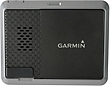
Garmin nuvi 500
Garmin nuvi 500 is a very small device - 7.6 ounces, measure 3.4 by 4.2 by 0.9 inches and feature a 3.5-inch, 320-by-240-pixel screen. The 500 is rated IPX7 waterproof, which means it can be submerged in water to a depth of one meter (3.3 feet) for 30 minutes without sustaining any damage. Moreover, the nuvi 500 includes a waterproof built-in speaker that provides more than adequate volume for spoken turn-by-turn directions.
Nuvi 500 includes topographic maps as well as street-level maps for turn-by-turn navigation for the 48 contiguous states, Hawaii, and Puerto Rico. You can purchase a DVD with topographic maps that you can download onto your own microSD card for $116.65, or you can buy any of the 11 regional topographic maps on microSD cards at $86.14 each directly from Garmin. You can also upgrade either of the units with the optional BlueChart g2 Vision and Inland Lake Vision maps, which provide detailed marine information.
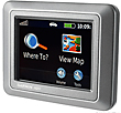
When you power up the nuvi 500 the main screen is almost identical to that of every other nuvi screen. You're greeted with the familiar "Where to" and "View Map" large icons, along with smaller icons at the bottom of the screen that will let you control the volume setting and access the setup menu. On top there is a four-bar GPS signal strength indicator. Tapping the signal bars doesn't bring up the GPS status, and there's no GPS status option under the Tools menu, so there's really no way to see how many satellites you're tracking. You can, however, determine the GPS accuracy by checking the compass view without an active route.
The main menu screen also includes a new Mode icon located in the center at the top of the screen. A tap lets you change between driving, walking, and bicycling mode. You can store your routing, map view, and cursor icon preferences for each of the three modes. For the walking and bicycling modes, you have a choice of on road or off road. For driving mode, your choices are faster time, shorter distance, or off- road. In driving mode you can also enable your choice of avoidances from nine options, which include toll roads, ferries, HOV lanes, and others.
If you're walking or riding a bicycle, the 500 adds a compass view when you're navigating. You can switch back and forth between the map view and the compass view en route to each of the geocaches. On the nuvi 500, the four data fields in the compass view are fixed to the following modes: speed, elevation, time, and distance to arrival. Unfortunately, the distance-to-arrival field was never populated, so the only way you can see if you are approaching the geocache is to use the map view, which has an arrow showing the direction and the distance. The distance is shown in tenths of a mile until you get under one tenth, so you can walk a fair distance without knowing if you were walking toward or away from the geocache.
The geocaching features are excellent, the build quality is excellent as well. The system is stable and performs well. As a crossover device, the Garmin nuvi 500 represents a compromise both as an in-car navigator and an outdoor GPS. Garmin chose not to include text-to-speech for automotive mode, so the device doesn't pronounce street names. Also, there is no Bluetooth phone integration capability. Considering that the 500 is a device with outdoor enthusiast modes, it's a great choice for its affordable price. Garmin may be a very good choice for those who want the functionality of both an automotive and an outdoor enthusiast device.
|
|
|
 |
|
|
|
|
|
|