|
|
 |
Knowledge Is Key
For Intelligent Decisions
Satellite Logic is a leading,
authoritative source of information in
the Satellite Industry. Located in the
heart of the Silicon Valley, Satellite
Logic provides one of the most
valuable and comprehensive
knowledge bases on the Satellite
market! This is a primary Worldwide
information center which enables our
clients to analyze, evaluate, inquire
and select their best tailored
solutions. Our company sets the
industry standards for targeted
buying leads, reflecting a dramatic
advance over traditional marketing
solutions.
|
|
|
 |
 |
|
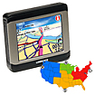
Lowrance XOG Lakes Bundle Road-Trail-Water GPS
Lowrance announced the XOG Cross-Navigation GPS device. The XOG is intended for the outdoors enthusiast who also needs in-car turn-by-turn navigation.
The XOG features a 3.5-inch (diameter) touch screen in an IPX4 splash proof water-resistant case. The built-in 2GB of memory includes Navteq street level detail maps for the US and Canada as well as over three million Points of Interest (POI). The XOG also features an MP3 player and JPEG picture viewer.
For the outdoors Lowrance offers an extensive library of affordable optional maps from either its online store or as pre-programmed SD cards that plug into the XOG's card slot. Available maps from the online store are two-meter Satellite Imagery, 1:24K USGS Topographic maps, and 1:100K BLM maps; the pre-programmed SD cards are FreedomMaps (topographic), fishing hotspots, LakeMaster, MauticPath and Navionics.
Taking a new direction in precision, all-purpose navigation, the innovative new Lowrance XOG crossover road-trail-water, 12-channel GPS features ready-to-go street navigation and loads of optional outdoor maps. Rugged, weatherproof, fully portable and super-accurate with multimedia extras, the new XOG is the one-for-all companion for all your travels. Inside the car, on the trail, or in the boat!
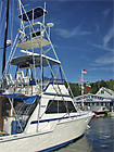
Now you can get detailed maps for over 3000 lakes - all on one chip! Navionics HotMaps Handheld provides bottom contours, structure, reefs, drop-offs, vegetation, boat ramps, marinas and more. Plug-and-play cartridge is ready to use, no CDs, downloads or unlock codes required.
Features:
Bright, 3.5" (8.89 cm) diagonal 16-bit color touchscreen display
320H x 240V pixel resolution
Super-bright, white LED backlit screen
Simplified touch-screen menus
Three selectable mapping displays: 2-D Track Up, 2-D North Up, and Elevated 3-D
Navigation/Mapping
Internal, precision 12-channel GPS antenna with superior tracking sensitivity
Built-in, turn-by-turn NAVTEQ street Navigation detail with voice and visual guidance, plus over 3 million POI destinations
Supports all current plug-&-play map/chart options from Lowrance (FreedomMaps, Fishing Hot Spots PRO, LakeMaster ProMaps, and NauticPath), as well as Navionics Classic and Gold charts
Unique, downloadable maps with U.S. satellite and aerial imagery, enhanced USGS topographic data, and BLM mapping from online mapstore
Straight-line navigation feature for off-road, on-foot and marine use
Media Players
Full-featured stereo MP3 audio player for playing audio files loaded on an SD memory card
Full-featured picture viewer displays JPEG photos stored on SD memory cards
Get all that you need for the road and the lake navigation with this incredible GPS!
|
|
|
 |
|
|
|
|
|
|