|
|
 |
Knowledge Is Key
For Intelligent Decisions
Satellite Logic is a leading,
authoritative source of information in
the Satellite Industry. Located in the
heart of the Silicon Valley, Satellite
Logic provides one of the most
valuable and comprehensive
knowledge bases on the Satellite
market! This is a primary Worldwide
information center which enables our
clients to analyze, evaluate, inquire
and select their best tailored
solutions. Our company sets the
industry standards for targeted
buying leads, reflecting a dramatic
advance over traditional marketing
solutions.
|
|
|
 |
 |
|
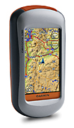
Garmin Oregon 200
Garmin Oregon 200 is an all-terrain navigator featuring a high-sensitivity receiver and microSD card slot. Garmin Oregon 200 touch screen provides an easy to use intuitive interface that puts all the information right at your fingertips.
The Oregon 200 comes loaded with a basemap and high sensitivity, WAAS capable receiver. The microSD card slot lets you load additional maps including topographic maps, street maps and state of the art BlueChart G2 Vision for marine navigation. Get depth contours, harbor information and navigational aids or turn by turn directions of city streets. You can also upload Geocaching.com GPX files for family fun or solo geocaching exploration.
The rugged, waterproof, dustproof, dirtproof case makes the Oregon 200 a must have navigational aid for just about any outdoor adventure. Its slim, lightweight design makes it easy to slip into a pocket or a backpack.
Switch easily between multiple coordinate systems, languages and mobile statistics. See your average moving speed, best fishing times, sunrise, sunset, moonrise and moonset times, and monitor the distance to your next waypoint. You can even show off your biggest catch, cutest baby pics or scenic waypoint with the built in picture viewer.
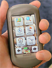
The Garmin Oregon 200 leads the way with a tough, 3-inch diagonal, sunlight-readable, color, touchscreen display. Its easy-to-use interface means youll spend more time enjoying the outdoors and less time searching for information. Both durable and waterproof, the Garmin Oregon 200 is built to withstand the elements. Bumps, dust, dirt, humidity and water are no match for this rugged navigator.
Since the Garmin Oregon 200 supports Geocaching GPX files for downloading geocaches and details straight to your unit, no more manually entering coordinates and paper print outs! Simply upload the GPX file to your unit and start hunting for caches. As mentioned before, just show off photos with Oregons picture viewer. Slim and lightweight, the Garmin Oregon 200 is the perfect companion for all your outdoor pursuits.
With its high-sensitivity, WAAS-enabled GPS receiver and HotFix satellite prediction, the Garmin Oregon 200 locates your position quickly and precisely and maintains its GPS location even in heavy cover and deep canyons. The advantage is clear: whether youre in deep woods or just near tall buildings and trees, you can count on Oregon to help you find your way when you need it the most.
Conveniently plug in optional preloaded microSD cards for all your outdoor activities on land or water. Just insert a MapSource card with detailed street maps, and the Garmin Oregon 20 provides turn-by-turn directions to your destination. Add select topographic maps to take advantage of Oregons 3-D map view which gives you a better perspective of your elevation. With BlueChart® g2 Vision, youll get everything you need for a great day on the water including depth contours, navaids and harbors. The card slot is located inside the waterproof battery compartment, so you don't have to worry about getting it wet.
Features
* Large 3" touch screen daylight viewable TFT screen - 38 x 63mm and 240 x 400 pixels.
* 5 Special user modes: Automotive, Marine, Recreation, Fitness or Geocaching.
* Trip Computer: current speed, average speed, resetable maximum speed, trip timer and distance.
* Anchor Drag, Arrival & Off course Alarms.
* 1000 waypoints with name and graphic symbol, 10 nearest (automatic) and 10 proximity.
* 50 reversible routes of upto 250 waypoints.
* Tracklog Points: 10,000.
* Area calculation feature calculates the size of an area that has been circumnavigated. Ideal for measuring areas of fields, bodies of water etc.
* Best Hunting and Fishing Times.
* Stopwatch & Lap timer functions.
* Waterproof case to IPX7 standard.
* Major highway map of Australia.
* City Navigator, TOPO Australia and MapSource BlueChart Pacific CD data options.
* 24mb Internal Memory & microSD External Memory slot.
* JPEG image viewer can display pictures from microSD card.
* Battery Life: 2 AA's (not included) up to 16 hours.
* Supplied with PC/USB Interface cable & Carabiner Clip.
Garmins Oregon series of handheld units sets the standard for next generation outdoor GPS navigation systems and this slim navigator boasts the brightest, sharpest, most colorful graphics you've ever seen on a 5-inch screen. Get it now, it's a great value for your money.
|
|
|
 |
|
|
|
|
|
|