|
|
 |
Knowledge Is Key
For Intelligent Decisions
Satellite Logic is a leading,
authoritative source of information in
the Satellite Industry. Located in the
heart of the Silicon Valley, Satellite
Logic provides one of the most
valuable and comprehensive
knowledge bases on the Satellite
market! This is a primary Worldwide
information center which enables our
clients to analyze, evaluate, inquire
and select their best tailored
solutions. Our company sets the
industry standards for targeted
buying leads, reflecting a dramatic
advance over traditional marketing
solutions.
|
|
|
 |
 |
|
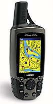
Garmin GPSMAP 60Cx
On the outside the GPSMAP 60Cx looks like the 60Cx. But there are significant changes inside, most of them for the better. The main difference though is that the CSx includes a barometric altimeter and an electronic compass. The higher version is slightly larger and comes with a "transflective" screen, which makes reading the screen in full sunlight is a bit easier. While both GPS navigation systems are waterproof in their cases, only the 60Cx will float.
Also worth of notice is that the 60Cx has more satellites and better signal strength, but an accuracy reading of 21 feet. The 60Cx has fewer satellites and poorer signal strength on the satellite page, though it shows an eleven foot accuracy. Both are getting WAAS correction, shown with the "D" on each satellite bar. It doesn't mean however that one unit is reading more accurately than the other. The EPE - ESTIMATED POSITION ERROR is no more accurate than the basic accuracy of the unit itself and it depends on which satellites are being viewed by each unit and their accuracy at that moment. With the basic accuracy of WAAS on these units being 3 meters, (about 10ft) you can conclude that the accuracy of the 60CS is 11ft.
The Garmin GPSMap 60Cx sits at the high end of Garmin's handheld line. It has lots of features and does a pretty good job in maintaining its position. The unit comes with a relatively large screen for a handheld, making it easier to read the map. The SiRF star III chipset is fed through the bulbous helix antenna for excellent reception in all kinds of situations, and the expandable micro-SD card storage system allows you to take a lot of maps and data with you on your trip.
Because of its size, the GPSMap 60Cx is certainly a portable handheld device, but not exactly pocketable. Anyone not absolutely fixated on portability will enjoy the extra screen real estate and the luxury that the SiRF star III chipset can bring in terms of no-doubt satellite reception.
The GPSMAP 60Cx is in fact an improved Garmin handheld GPS Receiver. The two key features of the 60Cx include the ability to upgrade the map memory with a larger microSD card and the addition of a Sirf star III receiver chip, which dramatically improves satellite reception. The Sirf Star III chip is the most noticeable change in the 60Cx. Acquisition times are very fast, even with a cold start, typically less than 30 seconds.
The GPSMap 60Cx is loaded with features, and the primary difference that separates it from its 60Cx sibling is the added electronic compass and barometric altimeter functionality. Both come with the SiRF star III chipset, the big screen, microSD slot and great GPS capabilities. The on/off button is placed at the top of the unit next to the antenna. The unit has a series of buttons across the bottom that allows you to access the most used features easily and quickly. At the top of the arc on either side, you get a + and a - button that allows you to zoom in and out on map pages. Going down the left side you have the Find button which brings up dialogue for finding waypoints, and Points of Interest, like towns, geographical features, etc. The button also functions as a Man Over Board button when held down.
The unit will then mark the location of a man over board and then navigate back to that location. The Mark key is next, which allows you to mark your location as a waypoint. Enter and then Menu are classic software navigation keys that are very handy to have access to. Lastly the Page button allows you to flip through the various pages that you can pull up and look at.
On the backside of the unit you have three ports: 1) The Mini-USB connection, 2) an aux antenna port, and 3) a serial external data port. The unit also has a lanyard holder and the battery door where you access the two AA batteries, under which there is the tiny microSD cardholder. The unit is waterproof to IPX7 standards (1 meter of water for an hour), which essentially keeps you safe in rain and splash situations. The 60Cx is rated for 15 hours of use on a pair of batteries, which is pretty good, but is probably driven down by the big screen its using.
The ability to upgrade the memory is a huge improvement to a handheld unit. In the 60CS, you have 56 MB of memory available. In the 60Cx the included microSD card, (found underneath the batteries) is a 64MB card. However, it will accept up to a 1GB microSD card, meaning that you can load just about as much map memory as you could ever want, up to two thousand and twenty five (2025) separate map files.
Another improvement with the 60Cx, is that you can power the unit through the USB port. When you connect it to the computer through the USB, it will power the unit. You can also power it through a Garmin USB DC power cable. There are both AC and DC type adapters available from Garmin as additional accessories.
Garmin says the average battery life in the 60Cx is 18 hours. In the 60CS, you can expect at least 20 hours of use. Using WAAS will reduce this some as well as extensive use of the backlight.
The 60Cx does not contain at least three features found in the 60CS. The alarm clock is gone, as is the ability to set a pressure trend recording. In the marine features, the speed filter in the 60CS is also not included. And in using a 60Cx in APRS, a amateur radio hobby, the 60Cx does not overwrite when a new station is heard and downloaded into the unit. It simply adds a number to the end of the waypoint station. This can overload your waypoint capacity of 1000 within a couple of hours. Garmin says there is no way to get the unit to overwrite the stations. However, you can easily manage this by not giving any of your other waypoints the Blue Flag icon. Then delete only the icons that are Blue Flags as needed, to keep the stations from overloading your waypoint capacity.
Bottom line - the 60Cx is a great handheld GPS device. When it comes to outdoor use it is the most versatile GPS receiver. The ease of getting and keeping GPS reception, as well as the ability to increase map memory are very nice features. Plus you can automatically save tracklogs to the data card. Get it now, it's an excellent value for the money.
|
|
|
 |
|
|
|
|
|
|