|
|
 |
Knowledge Is Key
For Intelligent Decisions
Satellite Logic is a leading,
authoritative source of information in
the Satellite Industry. Located in the
heart of the Silicon Valley, Satellite
Logic provides one of the most
valuable and comprehensive
knowledge bases on the Satellite
market! This is a primary Worldwide
information center which enables our
clients to analyze, evaluate, inquire
and select their best tailored
solutions. Our company sets the
industry standards for targeted
buying leads, reflecting a dramatic
advance over traditional marketing
solutions.
|
|
|
 |
 |
|
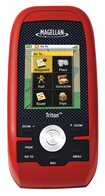
Magellan Triton 500
GPS navigation isn't just for motorists. You can use handheld units for a lot of challenging activities. Practically you can go with a handheld GPS from point A to point B even in the woods or on a lake. Got a topographical map? No problem, now you can even pinpoint your location on the local terrain.
These small devices will display a route as a straight line, so it's up to you to avoid obstacles such as steep drops and rivers. They do record your route for return-trip guidance, and you can share your coordinates in case of an emergency.
Some can also display other information, such as hunting, fishing, and sunrise/sunset calendars. You may even try Geocaching - a growing hobby involving treasure hunting on the trail.
Made for the brave outdoorsmen the Magellan Triton 500 is a handheld device loaded with lots of features. Whether you are hunting, hiking, camping, or simply geocaching, the Triton 500 will safely guide you along your trip. The high sensitivity WAAS SiRFstar III GPS receiver will keep you on track, even under heavy tree cover. The Triton 500 also features a 3-axis electronic compass for accurate headings even when standing still. The embedded barometer will allow you to track changes in weather and elevation. If you get caught in bad weather, have no fear as the Triton 500 is fully waterproof to IPX-7 standards and has a rugged outer casing for ultimate protection.
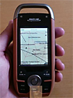
The Triton 500 is also compatible with National Geographic TOPO! maps. With an SD card storage slot, you can hold a large area of National Geographic maps on an optional SD card and once the card is plugged into the GPS that detail will show on the Tritons display. National Geographic Topo! State Series Maps are the first software to offer 1:24,000 scale mapping for the entire US that can be downloaded into a handheld GPS. These maps are downloadable onto the Magellan Triton Series handheld GPS where you can view your location on the crisp 24k USGS maps in real time. This software will also allow you to view lat/lon or UTM grids, view trail profiles along with elevation gains or losses and find trails, parks, summits and campsites all on your PC. You can even customize the maps by adding your own notes and photos.
The Magellan Triton GPS series is built for precision navigation, offering ultrafast GPS positioning acquisition using the SiRFstarIII chipset. Each Triton features a high-resolution color display. Unlike other complicated devices that require you to scroll through page after page, the Triton gets you to the information you want in a few clicks. Quickly view all your maps, locations and saved tracks and waypoints using the intuitive user interface and direct-access buttons.
An integrated high-sensitivity antenna provides reliable signal reception even in heavy cloud cover, canyons or deep woods. Built-in signal augmentation reception (WAAS/EGNOS) ensures accuracy to within three meters. Rugged and waterproof, the Triton is built to withstand intense use, accidental impact and immersion in one meter of water for up to 30 minutes. The advanced features are also easy to use. You can view the elevation profile for the trail ahead or for any route, find the precise time of sunrise/sunset any day of the year and get a calculation of the best hunting and fishing times.
Exclusive VantagePoint software lets you easily manage user-generated content, updates and upgrades on your PC with the included USB cable. Plus, Triton is the first handheld GPS to offer compatibility with National Geographic maps (sold separately). These highly detailed, high-definition, nationwide topographic maps based on USGS 1:24,000 series quads, offer seamless scalability, multilayer overlays and much more.
The Triton Series is the first handheld to feature 1:24,000 high-resolution map details. Large 2.2" brilliant color screen on the Triton 500. Use it to control navigation and advanced features with just a touch. Unit features a three-axis electronic compass and barometric altimeter. It also boasts SD-card compatibility to maximize your data storage options. Add an unlimited amount of marine cartography and National Geographic topographic maps to navigate all the places you want to explore. Runs on two AA batteries.
Magellan Triton 500 Features:
2.2-inch full colour QVGA display
Pre-loaded basemap of Europe
Directional pointer and compass
Highly intuitive user interface
3-axis electronic compass
Built-in barometer
WAAS/EGNOS-enabled
SiRFstarIII GPS antenna with 3-5 metre accuracy
Extremely rugged and waterproof to IPX-7 standards
2 AA batteries (not included) provides 10 hours of use
Weighs 187 grams with batteries
USB 1.1 for transferring data
The Triton 500 is so easy to use that you'll find the manual almost useless. The unit will run off of 2 AA batteries for up to 10 hours. The pre-loaded map database includes detail for North America, as well as geographic boundaries worldwide. Other features include best times for fishing and hunting, sun and moon phases, and vertical profiles. So grab it now and change your outdoors life forever.
|
|
|
 |
|
|
|
|
|
|