|
|
 |
Knowledge Is Key
For Intelligent Decisions
Satellite Logic is a leading,
authoritative source of information in
the Satellite Industry. Located in the
heart of the Silicon Valley, Satellite
Logic provides one of the most
valuable and comprehensive
knowledge bases on the Satellite
market! This is a primary Worldwide
information center which enables our
clients to analyze, evaluate, inquire
and select their best tailored
solutions. Our company sets the
industry standards for targeted
buying leads, reflecting a dramatic
advance over traditional marketing
solutions.
|
|
|
 |
 |
|
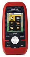
Magellan Triton 400
Magellan Triton 400 handheld GPS system is another one of Magellan's easy to use units. It has simple menus, instant access buttons, intuitive scroll pad and crystal clear graphics on a 2.2-inch full colour display. The Magellan Triton 400 includes a pre-loaded basemap of North America and worldwide geographic boundaries.
Triton 400 is perfect for the first-time GPS user. And the full-color display, SD-card compatibility, enhanced features, fast signal acquisition, reliable signal lock and precision positioning make Triton 400 an excellent choice for the advanced navigator.
SD-card compatibility maximizes your navigation capability. Add an unlimited amount of marine cartography, topographic maps and other content to navigate all your outdoor adventures. Plus, Triton is the first handheld GPS to offer compatibility with National Geographic maps. These highly detailed nation-wide topographic maps based on USGS 1:24.000 series quads, offer seamless scalability with customizable multi-layer overlays and much more.
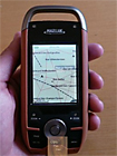
The smartly designed interface with simple menus and intuitive button and scroll pad control make navigation fun and effortless. The full-color crystal clear display shows all your maps and navigation information in brilliant, easy-to-view graphics. Instantly see all your maps, locations and saved tracks and waypoints with just a click or two. Unlike other complicated devices that require you to scroll through page after page, Triton 400 gets you to the information you want with a few keystrokes.
Exclusive VantagePointT software enables easy management of maps, user generated content, updates and upgrades on your PC. View saved routes and tracks. Customize them for future trips or create new ones.
Triton is designed for precision navigation, offering the fastest GPS positioning acquisition in the industry with the SiRFstarIII chipset. An integrated high-sensitivity antenna provides reliable signal reception even in heavy cloud cover, canyons or deep woods. Built-in signal augmentation reception (WAAS/EGNOS) provides 3-meter accuracy.
Rugged and waterproof, your Triton 400 is built to withstand intense use, accidental impacts and immersion in one meter of water for up to 30 minutes (IPX-7). It's ready to guide you on any adventure.
The advanced features are also easy to use. View the elevation profile for the trail ahead (or any route) or even the track you just traveled. See the precise time of sunrise/sunset any day of the year. Get a calculation of the best hunting and fishing time. And much more.
Triton is built on the experience of hundreds of thousands of GPS users and nearly 20 years of precision positioning technology from Magellan: the first name in navigation.
Magellan Triton 400 Features
Amazing ease-of-use - Reinventing handheld GPST, simple menus, instant access buttons, and crystal clear graphics let you navigate without the need for specialization
Full-color 2.2" display - The large display shows maps, simple menus, navigation screens and other data in brilliant color
SD-card compatibility - An invaluable feature enables you to use an unlimited amount of map data for topographic and marine navigation. Store tracks, routes, geocaches and more
Add detailed maps - Upload optional marine cartography, topographic maps, and more, including the highly-detailed and feature-packed National Geographic Maps to the available memory or SD card
Built-in maps - Basemap of the 48 contiguous United States, Alaska, and Canada (major highways, city centers, parks, lakes and more) plus worldwide geographic boundaries
Points of interest - Preprogrammed points of interest include parks, city centers, airports, historical monuments and more
Compass screen - See your direction of travel, distance and position of destination, heading, bearing, speed and more on the beautiful graphic compass
3-meter accuracy - SiRFstar III chipset and integrated multidirectional antennae offer superior GPS accuracy using the Wide Area Augmentation System
Whether you're a first time handheld GPS user or an experienced user, we highly recommend it.
|
|
|
 |
|
|
|
|
|
|