|
|
 |
Knowledge Is Key
For Intelligent Decisions
Satellite Logic is a leading,
authoritative source of information in
the Satellite Industry. Located in the
heart of the Silicon Valley, Satellite
Logic provides one of the most
valuable and comprehensive
knowledge bases on the Satellite
market! This is a primary Worldwide
information center which enables our
clients to analyze, evaluate, inquire
and select their best tailored
solutions. Our company sets the
industry standards for targeted
buying leads, reflecting a dramatic
advance over traditional marketing
solutions.
|
|
|
 |
 |
|
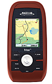
Magellan Triton 300
The Magellan Triton 300 is part of the company's lower price-point models of handheld GPS receivers. It is ideal for hikers and many other outdoors activities. It features a 2.2-inch full colour display screen, pre-loaded maps and the ability to load compatible third-party maps and a positioning system which identifies major landmarks such as lakes, rivers and cities. The device is waterproofed to IPX-7 standards and is structured to absorb accidental physical damage.
Although on the lower side, the Triton 300 is part of Magellans groundbreaking Triton Family of handheld GPS units. With an updated design and easy to use operation, the Triton 300 is a must have unit for any outdoor adventure. The generous 2.2 color display is sunlight viewable and is built into a rugged, waterproof case. The highly sensitive SiRFstar III WAAS GPS receiver will provide unsurpassed satellite tracking, even in heavy tree cover. Powered by just 2 AA batteries, the Triton will run for up to 10 hours on one set.
The Triton 300 is also compatible with National Geographic TOPO! maps. National Geographic Topo! State Series Maps are the first software to offer 1:24,000 scale mapping for the entire US that can be downloaded into a handheld GPS. These maps are downloadable onto the Magellan Triton Series handheld GPS where you can view your location on the crisp 24k USGS maps in real time. This software will also allow you to view lat/lon or UTM grids, view trail profiles along with elevation gains or losses and find trails, parks, summits and campsites all on your PC. You can even customize the maps by adding your own notes and photos. The detailed maps can be loaded the Magellan Triton 300s 10 MB of onboard storage.
The Triton 300 is so easy to use you will not need a users manual. The pre-loaded map database includes detail for North America, as well as geographic boundaries worldwide. Other features include best times for fishing and hunting, sun and moon phases, and vertical profiles.
The Magellan Triton 300 is amazingly easy to use with a smartly designed interface and simple menus that make navigation fun and effortless. The full-color crystal clear display shows all your maps and navigation information in brilliant, easy-to-view graphics. Instantly view all your maps, locations and saved tracks and waypoints using the intuitive scroll pad and direct-access buttons. Unlike other complicated devices that require you to scroll through screen after screen, Triton 300 gets you to the information you want in two or three clicks.
The exclusive VantagePoint software enables easy management of maps, user generated content, updates and upgrades on your PC. View saved routes and tracks. Customize them for future trips or create new ones.
Add detailed maps and applications to the available memory and further enhance your navigation experience. Plus, Triton is the first handheld GPS to offer compatibility with National Geographic maps. These highly detailed nation-wide topographic maps based on USGS 1:24.000 series quads, offer seamless scalability, multi-layer overlays and much more. Both the TOPO! State series and the Weekend Explorer 3D series products are compatible with the Triton 300.
The Magellan Triton 300 GPS is designed for precision navigation, offering the fastest GPS positioning acquisition in the industry with the SiRFstarIII chipset. An integrated high-sensitivity antenna provides reliable signal reception even in heavy cloud cover, canyons or deep woods. Built-in signal augmentation reception (WAAS/EGNOS) provides 3-meter accuracy.
Rugged and waterproof, the Triton 300 is built to withstand intense use, accidental impact and immersion in one meter of water for up to 30 minutes (IPX-7). The advanced features are also easy to use. View the elevation profile for the trail ahead (or any route) or even the track you just traveled. See the precise time of sunrise/sunset any day of the year. Get a calculation of the best hunting and fishing time.
Features:
* Built-in maps - Basemap of the 48 contiguous United States, Alaska, and Canada (major highways, city centers, parks, lakes and more) plus worldwide geographic boundaries
* Add detailed maps - Upload marine cartography and topographic maps, including the highly-detailed and feature-packed National Geographic Maps
* Points of interest - Preprogrammed points of interest include parks, city centers, airports, historical monuments and more
* Full-color 2.2" display - The large display shows maps, simple menus, navigation screens and other data in brilliant color
* Compass screen - See your direction of travel, distance and position of destination, heading, bearing, speed and more on the beautiful graphic compass
* Device dimensions - 4.65" x 2.16" x 1.22" (11.8 cm x 5.5 cm x 3.1 cm).
|
|
|
 |
|
|
|
|
|
|