|
|
 |
Knowledge Is Key
For Intelligent Decisions
Satellite Logic is a leading,
authoritative source of information in
the Satellite Industry. Located in the
heart of the Silicon Valley, Satellite
Logic provides one of the most
valuable and comprehensive
knowledge bases on the Satellite
market! This is a primary Worldwide
information center which enables our
clients to analyze, evaluate, inquire
and select their best tailored
solutions. Our company sets the
industry standards for targeted
buying leads, reflecting a dramatic
advance over traditional marketing
solutions.
|
|
|
 |
 |
|
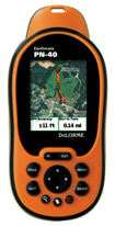
DeLorme Earthmate PN-40
A useful and relaible handheld GPS fits the needs of most daysailors, racers, and weekend cruisers and at less cost than a fixed chartplotter. With updated charts, even basic handhelds provide the necessary information. For most cruisers and bluewater sailors, a handheld is good to have as a backup to the primary chartplotter or for emergency use in a life raft.
One of the newest additions to the handheld electronics market is the Earthmate PN-40 GPS by DeLorme, a Maine-based manufacturer of mapping products and technologies for the consumer and professional markets.
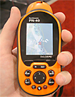
The DeLorme Earthmate PN-40 is an NMEA-compliant, 32-channel GPS receiver outfitted with a variety of display options, including up-to-late DeLorme Topo USA topographic maps, color aerial imagery, USGS 7.5-min. topographic quad maps, and NOAA nautical charts. It features an STMicroelectronics Cartesio chipset and DeLorme ConstantLock technology, allowing it to acquire satellite images quickly and retain them in the most difficult GPS environments. In addition, the Earthmate PN-40 boasts a plethora of outdoor tools, such as a 3-axis electronic compass, a sensitive barometer altimeter, and an on-board base map with major highways and thoroughfares, as well as secondary and connector roads (US only).
Additional features of the DeLorme Earthmate PN-40 GPS receiver include 500MB of internal flash memory, an SD card for an additional 32GB of memory, and support for 1000 user-defined waypoints, 50 routes, and 10 tracks.
The PN-40 is a color-screen, palm-sized GPS that uses 2-AA batteries. The PN-40 has a rugged, rubberized case and its waterproof to IPX 7 standard meaning you can dunk it under 1 meter of water for 30 minutes and it will still work. The screen is readable in all but the brightest sunlight though some map images were harder to read than others (more on that later). The buttons on the PN-40 give you quick access to the most commonly used functions like marking waypoints and searching for points of interest but can be difficult to press with gloved hands.
Since the PN-40 was designed for hikers and bikers it comes with an incredible set of topographic maps via the DeLorme Topo USA software. Ive been a fan of Topo USA for a while now - well before I tried the PN-40 - because it includes some of the clearest, most detailed outdoor maps available. You can transfer detailed topographic maps to the PN-40 to take on the trail, though unfortunately the process can be a bit tiresome using the slow serial-USB connection. The PN-40 comes with plenty of memory to fit detailed map coverage and you can add up to 32GB of additional memory though the SDHC slot.
Once youve loaded detailed maps on your PN-40 you can start using it as soon as you walk out your door thanks to its ability to provide driving directions. It wont talk to you like your Nuvi or Tom Tom but it will help you navigate to an unfamiliar trailhead. Once youre at the trailhead you can queue up a downloaded GPS track of the trail (Topo USA and the PN-40 support GPX formatted files) and follow it just as you would a road. The PN-40 even chirps like a bird when its time to turn - pretty outdoorsy if you ask me.
The PN-40 also has the (fairly) unique ability to view satellite and aerial imagery on the GPS itself. Youll need to download the imagery before you head out and the imagery isnt free (about $30 a year last I checked) but once youve loaded the images its like having Google Earth in the palm of your hand.
Features:
# NMEA-Compliant, 32-Channel
# STMicroelectronics Cartesio Chipset
# DeLorme ConstantLocok Technology
# 2.2 TFT Color Display Screen
# Worldwide Maps w/Major Highways
# Secondary and Connector Roads (US Only)
# Multiple Tracks, Waypoints, Routes
# 300MB Internal Flash Memory
# 32GB SD Card Slot
# Free Aerial Imagery
# Two AA Batteries (Not Included)
Of course the PN-40 also includes all the functions youve come to expect from an outdoor GPS - time, distance, speed, etc. but it also includes some helpful functions like a digital compass, barometric altimeter, and fishing and hunting functions. If youre looking for a good all-around GPS to use in the great outdoors and youre tired of paying for extras like detailed maps, the DeLorme Earthmate PN-40 is a good choice that wont damage your bank account.
|
|
|
 |
|
|
|
|
|
|