|
|
 |
Knowledge Is Key
For Intelligent Decisions
Satellite Logic is a leading,
authoritative source of information in
the Satellite Industry. Located in the
heart of the Silicon Valley, Satellite
Logic provides one of the most
valuable and comprehensive
knowledge bases on the Satellite
market! This is a primary Worldwide
information center which enables our
clients to analyze, evaluate, inquire
and select their best tailored
solutions. Our company sets the
industry standards for targeted
buying leads, reflecting a dramatic
advance over traditional marketing
solutions.
|
|
|
 |
 |
|
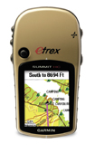
Garmin eTrex Summit HC
Garmin eTrex Summit HC is an affordable GPS navigator featuring a colour screen and high-sensitivity GPS receiver. The compact hand held unit has a built in basemap and 24MB of built-in memory to download additional TOPO GB and other MapSource software. The eTrex Summit HC also has an electronic compass and a barometric altimeter. The eTrex Summit HC is comparable to the monochrome eTrex Vista with the addition of the high sensitivity GPS receiver and a high resolution TFT colour display.
The rugged and waterproof Garmin eTrex Summit HC is a great geocaching tool and hiking companion! Whether youre looking for a GPS unit for your backpack, hunting pack or fishing box, the Summit has you covered. Its full color display is clear and easy-to-read, even in full sunlight. The 5.5 oz. unit features a molded grip and a sturdy case, and runs up to 14 hours on a set of 2 AA batteries. In geocaching mode, you can easily upload and pinpoint other peoples caches, and mark and report your own caches with a special icon.
The Summit HC maintains the diminutive size of the eTrex line. It measures only 4.2-inches tall, 2.2-inches wide, and 1.2-inches thick, making it easy to pack and carry. The screen measures 1.3-inces wide and 1.7-inches high with a 176 x 220 pixel resolution. The device is lightweight, with a pair of AAA batteries installed. Battery life is about 14 hours adequate, but far less than some of the newer high-end receivers.
Like all the eTrex models, the Garmin eTrex Summit HC is waterproof to IPX7 standards and can be submerged to a depth of 1 meter for 30 minutes without sustaining any damage. Plus, it is rugged enough for extended outdoor use.
Five menu buttons on the sides and a front mount joystick control navigation, allowing easy one-handed operation. However, the joystick placement makes right-handed use awkward.
The high-sensitivity receiver makes for fast acquisition of satellite signals, holding them even in challenging environments such as canyons or dense forests. The unit can store up to 500 waypoints and 50 routes. It allows 10,000 trackpoints and 10 saved tracks.
A basic basemap is included, with interstates, highways, airports, large cities and some smaller ones, oceans, rivers, and lakes. It also has an interstate exit database with some nearby points of interest such as gas station, hotels, and restaurants. The unit comes pre-loaded with the North America Basemap. The Summit lets you store up to 500 favorites, 50 routes, and 10 saved tracks for later use. Its high-sensitivity, WAAS-enabled receiver locates your position to within 10 feet, and the electronic compass and barometric altimeter help you stay on course. The altimeter also allows you to plot barometric pressure over the course of the day so youll know if foul weather is headed your way. The eTrex Summit HC is a great choice for your outdoor activities!
The real strength of this unit, however is the large 24 MB of internal memory, which allows you to load optional detailed maps from mapping software like Garmin's MapSource products. An included USB cable connects to a computer for this purpose.
The Summit HC is very intuitive and user-friendly. The information screens can be customized to show one's preferred data. A thoughtful feature is that the map screen will orient itself to the direction of travel, using the unit's electronic compass.
The barometric altimeter is great for hiking and backpacking, showing the current altitude and recording a trip elevation profile. It also helps predict weather patterns by tracking changes in barometric pressure. The built-in barometric altimeter and electronic compass keep elevation and direction information close at hand, perfect for hikers and climbers.
The Summit includes extras such as a Geocaching mode, outdoor GPS games, a hunting and fishing calendar for best times, and sun and moon information.
The Garmin eTrex Summit HC is a powerful mid-level handheld GPS device. Ideal for outdoor use, its many strong features provide accurate, reliable navigation for wilderness adventurers.
The eTrex Summit HC is comparable to the original monochrome eTrex Vista with the addition of a high-sensitivity GPS receiver and a high resolution TFT color display.
Like the rest of the eTrex series, Summit HC is lightweight and compact the perfect size for all your travels. Its waterproof, so it can withstand the elements or an accidental dunk in water.
eTrex Summit HCs basemap contains lakes, rivers, cities, interstates, national and state highways, railroads and coastlines. Summit HC also includes 24 MB of internal memory, so you can load waypoints and routes from the included MapSource Trip & Waypoint Manager software and add map detail from Garmin's entire line of optional MapSource mapping products. Its 256-color, sunlight-readable display makes it easy to distinguish map details even in bright sunlight.
Features:
# High-sensitivity GPS receiver for peak performance in any environment
# Barometric Altimeter and Electronic compass
# Rugged waterproof case (IPX7)
# WAAS enabled
# Built-in basemap
# USB compatible for high speed map downloads
# Compact size: 10.7x5.6x3.0cm
# High resolution TFT colour screen
# Display: 3.3 x 4.3cm; 176 x 220 pixels
# Stores 500 waypoints and 50 routes
# 24MB of built-in memory for adding additional map data using the optional Map Source mapping software
# Weight: 156g with batteries
# 4-way cursor for smooth one handed operation
# Multiple alarm functions
# Built-in celestial tables for best times to hunt and fish
# Area calculation
# User configurable colours and tones
# Find cities, exits, waypoints; with MapSource data, can look up addresses and attractions
A great device for outdoors activities.
|
|
|
 |
|
|
|
|
|
|