|
|
 |
Knowledge Is Key
For Intelligent Decisions
Satellite Logic is a leading,
authoritative source of information in
the Satellite Industry. Located in the
heart of the Silicon Valley, Satellite
Logic provides one of the most
valuable and comprehensive
knowledge bases on the Satellite
market! This is a primary Worldwide
information center which enables our
clients to analyze, evaluate, inquire
and select their best tailored
solutions. Our company sets the
industry standards for targeted
buying leads, reflecting a dramatic
advance over traditional marketing
solutions.
|
|
|
 |
 |
|
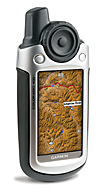
Garmin Colorado 400T
Whether you are locating treestands, hunting the backcountry or finding your way out of an unfamiliar area, the GPS revolution has made life much easier for big game hunters. Each year, GPS manufacturers add a number of features that are quickly adopted by those that spend a great deal of their time in the woods. Garmin has long been a leader in GPS technology and the Colorado 400t leaves little doubt that they are continuing to set the bar very high.
The first noticeable difference between the Colorado 400t and most other handheld GPS units is the large wheel located on the front of the unit. The wheel is very efficient in getting you from one place to another. This "Rock 'n Roller" wheel on the Colorado 400t makes menu navigation very easy. Instead of fumbling with various push-buttons that are found on the front and sides of most units, a quick spin of the wheel guides the user through menu choices. To ensure the user rarely has to concern themselves with any other buttons, a left, right, up or down command can be achieved by pressing on the corresponding part of the wheel and the middle acts like a select button.
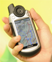
Marking waypoints with the Colorado 400t is simple and the unit is perfect for one handed operation. The Colorado 400t measures only 2.4" x 5.5" x 1.4" and weighs only 7.3 ounces, but it includes a vast range of functions. Detailed topographic maps (with 3-D map view), barometric altimeter, electronic compass, ability to accept an SD card, photo viewer, color display and the ability to share information wirelessly with other Colorado users are just a few of the many features. All that with menu shortcuts that make the GPS very user friendly.
The Colorado 400t not only provides high-quality U.S. topographic maps and a built in worldwide basemap with shaded relief, Garmin took it one step further by giving the user an option of a 3D view. Standard elevation lines will give you a general idea of the terrain, but the 3D view gives you a much better perspective. Being able to visualize the topography can save you a few good miles on your hiking boots.
The Colorado 400t includes a Hunt and Fish Page, which allows the user to select the date and determine the animal activity forecast for that day. Predictions range from Poor Day to Excellent Day along with the Best Times and Good Times during that day for success.
For many hunters Colorado 400t's ability to save 1000 waypoints, 50 routes and 20 tracks should be more than sufficient. Also, Garmin made the sharing information option easy by allowing the sharing of waypoints, tracks and routes with other Colorado users through the use of wireless technology. By holding the two units in close proximity and selecting send from the unit containing the information, the other unit receives the selected data.
Another unique and surprisingly handy feature of the Colorado 400t is the Area Calculator. Most big game hunters have tried their luck at putting in food plots. One of the critical elements in putting in a food plot is ensuring proper seed coverage. Too much and the plants will crowd each other. Too little and the plot might be overbrowsed. By simply selecting Area Calculation on the Colorado 400t and walking around the perimeter of the food plot site, the user can quickly determine the area of the plot and subsequently exactly how much seed is needed for maximum growth.
For hunters, weather info is essential. The built in altimeter can be used to plot barometric pressure over time. A Pressure Plot gives the user a quick visualization of changing weather conditions and allows them the opportunity to make decisions based on those conditions ensuring safety or increase the success of their hunt.
Navigation is extremely easy with the 400t. Simply selects Mark Waypoint from the shortcut menu with the Rock n' Roller. The point is assigned a three-digit number, which can be edited to display any number or word that makes sense to the user. To go to that waypoint, the user simply selects the Where To? shortcut, selects Waypoints and then selects the desired waypoint from the list.
The Colorado 400t operates on two alkaline, NiMH or lithium AA batteries. Battery life is dependent on many factors including display brightness, frequency of use and amount of satellite searching, but averages about 15 hours. One thing a user will quickly notice is that each time the unit is turned on, the display backlight defaults to the lowest setting. A quick tap of the power button allows you to adjust the setting, but having to do this each time the unit is powered up becomes a minor annoyance.
The Colorado behaves like the newer Garmin automotive units, such as the nuvi, when you connect it to a computer. It automatically switches into Mass Storage Device mode. You can still send maps, waypoints, tracks, and routes from MapSource. As of software version 2.51 Beta, the Colorado now offers support with Garmin's Spanner, and running this software and changing the interface in the system settings will allow you to plug it into the computer and use nRoute or other NMEA type programs. You will then be prompted whether you want to go into mass storage mode, which is required to send/receive tracks in Garmin's MapSource.
The Colorado 400t has built in maps and the version is listed as: US TOPO 2008 maps. It is a file that is about 2.7GB which is loaded on the unit. I also loaded in National Parks 24K maps and it is really incredible to see, especially with the shaded relief. The higher detail maps seem to be why, which shows us the Colorado is capable of good things.
Whether you are a weekend hunter or fulltime guide, you will undoubtedly find the Garmin Colorado 400t to be a valuable addition to the backpack. With its innovative features and user-friendly design, chasing big game and finding your way home just got a little easier.
The Garmin Colorado 400t is a big step forward in handheld GPS receiver design. We like the Colorado 400t's iPod-like control wheel and intuitive interface, which is so intuitive that you don't even need to crack the user's manual. Definitely an excellent GPS you should test.
|
|
|
 |
|
|
|
|
|
|