|
|
 |
Knowledge Is Key
For Intelligent Decisions
Satellite Logic is a leading,
authoritative source of information in
the Satellite Industry. Located in the
heart of the Silicon Valley, Satellite
Logic provides one of the most
valuable and comprehensive
knowledge bases on the Satellite
market! This is a primary Worldwide
information center which enables our
clients to analyze, evaluate, inquire
and select their best tailored
solutions. Our company sets the
industry standards for targeted
buying leads, reflecting a dramatic
advance over traditional marketing
solutions.
|
|
|
 |
 |
|
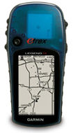
Garmin eTrex Legend H
Garmin's eTrex Legend H is known to have a high sensitivity receiver which can be clearly seen near the top of the unit. This receiver can get satellite fix under dense tree canopy or deep canyons. There are no fancy features in eTrex Legend H but youve still got the USB interface for uploading Topo maps.
eTrex Legend H has a 2.4? grayscale screen just like the eTrex Vista H which can be used to view basemap of North and South America, containing major lakes, rivers, cities, interstates, national and state highways, railroads and coastlines.
As one of the most versatile navigators around, the Legend H features a high-sensitivity GPS receiver that holds a signal in the toughest environments. The brightly-colored eTrex Legend H combines all of the intuitive, user-friendly features of the eTrex series with a detailed basemap and 24 megabytes (MB) of internal memory for storing optional maps.
The compact Garmin eTrex Legend H GPS also features easy-to-use rocker switch, 24 MB of built-in memory, crisp resolution and built-in basemap. High-sensitivity chipset delivers fast signal acquisition and lock for reception in narrow valleys, dense woodlands and urban jungles. Innovative rocker switch accommodates quick and accurate panning, selection and Enter functions.
Built-in memory allows you to download points of interest and detailed maps using Garmin MapSource software (sold separately); USB interface allows high-speed downloads. High resolution display features 4-level gray scale and high contrast for easy viewing. Includes a built-in general basemap and nautical navigational aids for North and South America. Track your route and find your way back with Garmin's exclusive TracBack feature. Store up to 1,000 waypoints with graphic icons. eTrex maintains tight satellite-lock, even through dense forest, by continuously tracking up to 12 satellites. Trip computer calculates current and average speed, sunset and sunrise, trip time and distance. Weatherproof body keeps eTrex functioning in wet conditions; waterproof to IEC 529 lPX7 standards. WAAS (Wide Area Augmentation System) enabled receiver delivers sub-3m accuracy. Comes with USB interface cable, lanyard, owner's manual and quick reference guide.
High-sensitivity, WAAS-enabled GPS receiver for peak performance in any environment
USB compatible for high speed map downloads
24 MB internal memory
Built-in basemap shows lakes, rivers, cities, major highways and interstates coastlines and landmarks
Compatible with mapping software including topographic maps and inland lake maps
Supports over 15 languages
High contrast screen with bright backlighting
Automatic track log saves up to 10 tracks to retrace your path
Stores 20 routes with up to 125 waypoints per route
Built-in celestial tables for best times to hunt and fish
Weighs only 5.3 ounces (150 grams) with batteries
Compact size: 4.4 x 2.0 x 1.2 (11.2 x 5.1 x 3.0 cm)
Up to 18 hours (typical use) on two AA batteries
Four-way cursor for smooth, easy one-hand operation
Display size: 2.4 diagonally, 160 x 288 pixels
Rugged waterproof case (IPX7)
Limited one-year warranty
The eTrex Legend H with its powerful receiver it's a great value for your money. Specially if you are after outdoors activities.
|
|
|
 |
|
|
|
|
|
|