|
|
 |
Knowledge Is Key
For Intelligent Decisions
Satellite Logic is a leading,
authoritative source of information in
the Satellite Industry. Located in the
heart of the Silicon Valley, Satellite
Logic provides one of the most
valuable and comprehensive
knowledge bases on the Satellite
market! This is a primary Worldwide
information center which enables our
clients to analyze, evaluate, inquire
and select their best tailored
solutions. Our company sets the
industry standards for targeted
buying leads, reflecting a dramatic
advance over traditional marketing
solutions.
|
|
|
 |

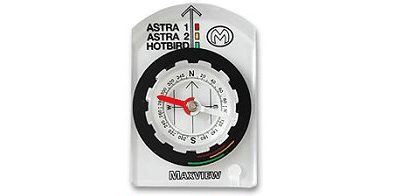
To use your satellite dish, you need not only to install it, but also to
align it. Aligning your satellite dish is much easier when you have an
idea of the direction of the satellite you wish to receive. Whether
youre a professional satellite TV installer or an amateur working at
home, you need a satellite compass. The satellite compass will save
you time in locating the direction your dish should be pointing to. In
fact, this tool is a must-have for satellite installers! Nothing is more
frustrating than finding out you have to move your Satellite dish
due to large trees or buildings obstructing the line of site.
To receive a clear picture, the dish must have the correct Vertical
(Azimuth) and Horizontal alignment. Vertical alignment, is the angle
of elevation above the horizon whereas the horizontal alignment of
a dish, is the compass bearing the dish will need to point.
The average features of a satellite compass are:
* Satellite alignment zone to help locate the direction of the satellite
signal
* Back-lit digital LCD display for low light viewing
* Distortion feature to identify magnetic fields causing possible error
to compass accuracy
* Suction pads for window mounting
* Time and temperature mode
* Back lit digital LCD display for low light viewing
* Compatibility with all satellite systems
The satellite compass is used by surveyors, engineers, cartographers,
geologists, miners, architects, satellite installers, and for anyone who
needs to be able to measure directional indications, heights, vertical
angles and slopes - with speed and accuracy.
The satellite compass is largely used for maritime purposes. Its
performance is not affected by ships speed, latitude, geomagnetism,
etc. The hybrid integration of GPS receiver technology and a 3-axis
solid-state rate sensor provide accurate and steady heading
information, even when bridges or tall buildings block satellite
signals. Unlike conventional magnetic and gyro compasses, accuracy
is not affected by G-force or velocity. Furthermore, when it has three
antennas, it provides enhanced accuracy while reducing the negative
effects of pitch, roll, and yaw.
The satellite compass is ideal as an alternative to a traditionally
expensive and high-maintenance gyrocompass for non-compulsory
vessels, as well as being the perfect back up solution to a gyro for a
compulsory vessel. It offers a wide range of applications for providing
fast, stable, precision heading information to numerous devices,
including: Radar/ARPA, Satellite Communications & TV systems,
Autopilots, AIS, ECDIS, Scanning Sonar, Chart Plotters, etc.
Satellite Compasses for the marine industry's transmitting heading
device combines inputs from conventional sensors and GPS satellite
signals to provide ships with a reliable, low-cost, geographic-north
oriented heading reference to meet the THD requirements. The
satellite compass processes signals received from GPS satellites
together with information from three integrated rate sensors, three
accelerometers and a magnetic field sensor and uses advanced
inertial navigation system algorithms to produce a stable and reliable
heading reference as well as rate of turn, roll, pitch, speed and GPS
position outputs in standard maritime message formats.
All output data can be interfaced to a wide range of navigation
equipment such as analogue and digital repeater compasses, radars,
autopilots, chart plotters, scanning sonars, automatic identification
systems (AIS), voyage data recorders (VDR), and steerable antenna
arrays. The system has an integrated heading monitor and a
user-selectable automatic alarm function.
The compact, economically priced compass systems are designed as
an alternative to conventional spinning-mass and fiber-optic
gyrocompasses for application on workboats, commercial fishing
vessels, large private yachts, naval patrol boats, and small
merchant ships, which are not required to carry a gyrocompass.
|
|
|
|