|
|
 |
Knowledge Is Key
For Intelligent Decisions
Satellite Logic is a leading,
authoritative source of information in
the Satellite Industry. Located in the
heart of the Silicon Valley, Satellite
Logic provides one of the most
valuable and comprehensive
knowledge bases on the Satellite
market! This is a primary Worldwide
information center which enables our
clients to analyze, evaluate, inquire
and select their best tailored
solutions. Our company sets the
industry standards for targeted
buying leads, reflecting a dramatic
advance over traditional marketing
solutions.
|
|
|
 |

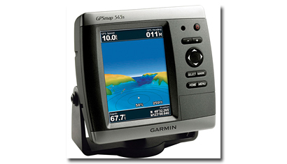
While for business travelers or drivers GPS systems can be very
useful, for fishermen, sailors, and ocean-going ships, marine GPS is
an essential safety device. For these people a marine GPS is much
more than providing routes and locations. It helps navigators avoid
underwater hazards and find their way during foggy and night-time
conditions, sometimes saving lives.
The features that are designed for marine GPS systems enable the
user to locate just what they need. Many GPS units offer built-in
mapping that includes lights, buoys, roads, airports, waterways,
complete coastal marine charts, and much more. There is up to 3
meters of tracking with marine GPS systems, and most provide
accurate longitude, latitude, bearing and knot coordinates.
Fisherman also use marine GPS to return to their favorite fishing
spot.
Boating has become a popular hobby that is enjoyed by many
people. There are many types of boats available for the average
person. Boats can be purchased for saltwater and freshwater
fishing, for water sports, for sailing, for long ocean cruises and for
a full-time residence. These boats range in price from a few
thousand to millions of dollars. Whatever the cost or use of the
boat, all boats should have basic boating equipment, including a
marine GPS.
One of the key features that differentiates marine GPS systems from
standard navigational units used in cars is that they are waterproof.
The battery and memory card compartments are designed to protect
them, and some marine GPS units will float if they are accidentally
dropped overboard. With a link to satellites, marine GPS units can
provide you with all the help that you are accustomed to receiving
from your car's navigational system. With large viewing displays easy
enough to use in the dark, a marine GPS can be depended on at any
time of the day or night. Marine GPS will clearly display information
on fishing and tide conditions, upcoming waypoints, travel, and
nautical data. Most marine units come sleek and compact, giving you
more space for other equipment you may need. These features
including ship-to-ship and ship-to-shore detection from marine
systems will help you stay safe and have fun.
In fact, a marine GPS can be the lifeline for your voyage if you find
yourself out in the middle of the high seas without a clue as to
where you are going. With a GPS, you can identify your exact
coordinates based on a number of electronic calculations and come
up with a strategy to get your vessel back where it belongs. This
type of technology can be a vital part to your vessels technological
arsenal and can be integral to voyage planning and determining
valuable ports of call. Marine GPS is responsible for saving many
lives and preventing many instances of being lost at sea from a
variety of untrained sources.
For example, our Coast Guard uses marine GPS systems to track
ships as they move up and down the coastlines. This enables them
to get a reading on where the ship is headed and what they are
heading for, allowing them to reach a point of communication with
the vessel to determine more information so as to properly guide
them to safety. Moreover, with the use of marine GPS technology,
it is possible to assist in planning routes for other ships and possible
to assist in avoiding collisions or other mid-water incidents.
The marine GPS market offers a wide range of GPS devices and
accessories. They vary from voice-activated computer systems to
simple radar-oriented GPS systems. They are popular with solo
mariners as the voice activated sounds provide kind of
companionship, even if it is simply the voice of the computerized
GPS giving directions and location signals. The radar GPS designates
blips and beeps as the signaling device, making it less personally
but equally as effective for purposes of finding locations and
coordinates.
Like with other GPS devices, you don't need a wealth of sea
knowledge to operate a marine GPS. Simply read the manual and
interpret the signals given on the GPS device; from there you will be
able to program your marine GPS device to the proper specifications
and create a user-friendly piece of technology that can assist your
voyage on the high seas. It is this simple operation and friendly
interface that makes a GPS system attractive for all vehicles types,
on land or off.
The uses of marine GPS are numerous. The most used feature of the
GPS device is location assistance. The marine GPS is used to get to a
location for a vessel, and then by following the GPS, getting the boat
back to where it started. This makes a day on the water much safer
than it used to be without this technology and eliminates much of the
safety risk that used to be a concern for boating hobbyists. Another
function of a marine GPS is to mark a location where the fish are
biting particularly well. This can be a particularly useful function for a
fisherman who can program the exact spot on the Marine GPS, which
will make it easier to find the next time he is out on the water.
Waypoints can also be added to the GPS, so that the fishing
enthusiast can stop at these points and check out the fishing.
Just as the civilian and personal side of marine GPS has grown, the
commercial side has made the marine GPS mandatory. Large fishing
vessels also use GPS to find fish and to navigate the ocean waters.
It can also help to keep the crew safe by avoiding storms and
directing boats on the safest route home. This use can and probably
has saved many lives, making it an essential piece of equipment for
the commercial vessels today. Another use for marine GPS is for
freighters and cruise ships. The GPS can be used to avoid potentially
dangerous obstacles in the ocean. While charts are still used quite
often by boats, these maps can be backed up by GPS to confirm the
actual place that the boat is located. This can help these large
vessels to confirm locations and avoid undersea obstacles. Oil spills
can become less of an issue if the captain knows exactly where they
are and how to avoid them.
Some marine GPS units also enable you to save the route that you
have mapped out on removable media cards. You may then be able
to transfer the information that you have saved to a computer. You
can also find marine GPS units available that transform your laptop
computer into a GPS system, which may be advantageous because
the monitor will be larger than what you will find on most GPS
systems.
|
|
|
|