|
|
 |
Knowledge Is Key
For Intelligent Decisions
Satellite Logic is a leading,
authoritative source of information in
the Satellite Industry. Located in the
heart of the Silicon Valley, Satellite
Logic provides one of the most
valuable and comprehensive
knowledge bases on the Satellite
market! This is a primary Worldwide
information center which enables our
clients to analyze, evaluate, inquire
and select their best tailored
solutions. Our company sets the
industry standards for targeted
buying leads, reflecting a dramatic
advance over traditional marketing
solutions.
|
|
|
 |

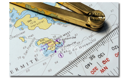
Whether you're operating a commercial ship or a recreational boat,
you should always carry onboard charts of the area in which you are
operating and you should know how to read them. These maps are
known as nautical maps.
A nautical map is a graphic portrayal of the marine environment. In
addition to its basic elements, a map or chart, is a working document
used by the mariner both as a "road map" and worksheet and is
essential for safe navigation. In conjunction with supplemental
navigational aids like GPS, it is used to lay out courses and navigate
ships by the shortest and most economical safe route. A chart
shows the nature and form of the coast, the depths of the water
and general character and configuration of the sea bottom,
locations of dangers to navigation, the rise and fall of the tides,
locations of man-made aids to navigation, and the characteristics
of the Earth's magnetism.
The United States claims 12 nautical miles for its territorial sea and
200 nautical miles fisheries jurisdiction and Exclusive Economic Zone
(EEZ) for the exploration and management of both living and
nonliving marine resources. This vast area covers approximately
3.4 million nautical square miles. OCS provides accurate and timely
nautical charts, maps, and related products for the coastal and
adjacent ocean areas of the United States (including possessions
and territories), the Great Lakes, other inland navigable waters,
for the safety and efficiency of marine transportation, offshore
engineering projects, naval operations, and recreational activities.
The update cycle for nautical charts is as often as every 6 months or
as infrequently as 12 years for remote areas. The average revision
interval per nautical chart is 2 years. The Cooperative Charting
Program involving the U.S. Power Squadrons and the Coast Guard
Auxiliary provides valuable feedback information on nautical charts.
Additional contacts are made through professional organizations,
technical conventions, boat shows, and similar activities. Marketing
studies are conducted to determine user reactions to existing
products and to formulate plans for new products, formats, and
coverage.
Many recreational boaters in small boats don't consider it important
to have charts onboard. They believe a GPS should be enough.
That's definitely a bad idea, even if you are just operating on your
local lake. Perhaps you are not yet a navigator, but a nautical map
onboard allows you to compare what you are seeing with what you
should be seeing and can help you keep your bearings.
Nautical charts are different from maps in that they specifically
depict water areas, while maps concentrate on land area, roads,
landmarks, etc. Land areas and features on charts are sketchy and
are noted only for their interest to the boater. Unlike maps, the
nautical chart conveys much information specifically designed to
assist in safely navigating the area that the chart covers.
Here are a few important tips for using nautical maps:
* Study your chart thoroughly
* Look at the position from which you will start and visually follow
along the course you wish to take
* Look for things like water depths, obstructions, bridges, power
lines or any other unusual items that may be a hazard
* Make note of all buoys and markers you may pass in the order they
will appear. This will give you a documented picture of your route and
what you should expect to see without having to continually try to
find a small marker on the chart
* Look for visual objects featured on your chart that you should be
able to observe and identify to confirm your position
* Always check the weather before departing
|
|
|
|