|
|
 |
Knowledge Is Key
For Intelligent Decisions
Satellite Logic is a leading,
authoritative source of information in
the Satellite Industry. Located in the
heart of the Silicon Valley, Satellite
Logic provides one of the most
valuable and comprehensive
knowledge bases on the Satellite
market! This is a primary Worldwide
information center which enables our
clients to analyze, evaluate, inquire
and select their best tailored
solutions. Our company sets the
industry standards for targeted
buying leads, reflecting a dramatic
advance over traditional marketing
solutions.
|
|
|
 |

The Global Positioning System (GPS) has been developed by the U.S.
Department of Defense to provide precise estimates of position,
velocity, and time. Today, the GPS technology serves both military
and civilian applications, unforeseen by the designers of the system.
GPS is the only system today that can pinpoint an exact location on
earth anytime, in any weather, almost anywhere. The 24 GPS
satellites, orbit at 11,000 nautical miles above. The satellites
transmit signals that can be detected by anyone with a GPS receiver.
Using the receiver, one can determine a location with great precision.
Initially, two kinds of GPS services were offered: Standard Positioning
Service (SPS) for open, unrestricted civilian use, and Precision
Positioning Service (PPS) for DoD-authorized users. For reasons of
national security, the civilian users had been limited to SPS, a
degraded subset of the signals. In May 2000, Former-President Bill
Clinton made it possible for civilians to get GPS signals that are nearly
as accurate as the military PPS. Most GPS users are now able to
identify their position within 20 meters, and some as close as 5
meters.
As far as the applications can be exposed publicly, the U.S. military is
applying GPS in a wide number of imaginative ways. Its interest in
GPS goes beyond navigation and tracking, developing systematic
new strategies for use in battle. New standards and regulations will
become available as dynamic GPS military applications continue to
unfold in areas of aircraft navigation, intelligence and target location,
weapon aiming, guidance systems and navigation warfare.

Picture the desert, with its wide, featureless expanses of sand. The
terrain looks much the same for miles. Without a reliable navigation
system, U.S. military forces could not have performed the maneuvers
of Operation Desert Storm. With GPS technology, the soldiers were
able to go places and maneuver in sandstorms or at night, when
even the troops who lived there couldn't. Other military applications
of GPS include:
* Guidance systems of a variety of missiles, bombs and artillery shells
are being deployed with GPS or differential GPS guidance - allowing
such weapons to accurately strike targets in any weather, day or
night, without operator intervention after launch
* GPS jamming systems are being developed to counter GPS
guidance systems
* GPS-homing seeker heads are under development to attack GPS
jamming transmitters
* Automatically GPS guided cargo parasail crafts are being created
that can be dropped at high altitude by a transport aircraft, and then
sail to a remote location, allowing the transport to remain out of
range of defenses around the landing zone
* GPS mapping systems are able to guide military troops and
equipment to the exact location of their adversaries
* GPS receivers within military aircraft, ships and submarines provide
numerous navigational advantages and the ability to identify the
precise position in space or at sea of their target
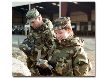
Today, GPS has become an indispensable component of both
America's war fighting machine. Civilians use GPS for aviation, survey/
mapping, scientific research, transportation, and maritime navigation,
just to name a few. In the military, GPS technology enables our
combat power to navigate with confidence and accuracy in any
conditions. When incorporated with other information management
systems such as the Inter Vehicular Information System (IVIS), it
also allows for the rapid dissemination and accurate plotting of
enemy positions.
GPS is also what makes America's fleet of unmanned aerial vehicles
(UAVs) so lethal. For instance, the Predator UAV's ability to plot
enemy positions to the nearest meter makes is as deadly as the
Hellfire missiles it carries. Guided munitions also benefit from GPS
accuracy; the JDAM, for example, is a 2,000 pound general purpose
bomb with a GPS receiver and movable control surfaces. It does not
radiate any EM/RF energy, or require a laser designator, and it is
in-flight reprogram-able.
The future of military GPS is very promising. Technology progress
and government policy changes have provided opportunities to
develop military GPS receivers with improved performance, improved
security and significantly reduced costs. Cell phone, personal
computer, and gaming console developments have pushed the
technology forward. The potential exists to achieve true force-
enhancing status for military GPS though the proliferation of low-
cost GPS.
|
|
|
|
