|
|
 |
Knowledge Is Key
For Intelligent Decisions
Satellite Logic is a leading,
authoritative source of information in
the Satellite Industry. Located in the
heart of the Silicon Valley, Satellite
Logic provides one of the most
valuable and comprehensive
knowledge bases on the Satellite
market! This is a primary Worldwide
information center which enables our
clients to analyze, evaluate, inquire
and select their best tailored
solutions. Our company sets the
industry standards for targeted
buying leads, reflecting a dramatic
advance over traditional marketing
solutions.
|
|
|
 |

Topographic maps are an invaluable tool for everyone from hikers
and campers to county planners and emergency response teams.
These maps are used by planners, engineers, outdoor enthusiasts,
and many others that rely on these to accurately depict the land
surface. During natural disasters, such a hurricanes, floods,
landslides, and earthquakes large numbers of topographic maps
are used by emergency response agencies and to assist recovery.
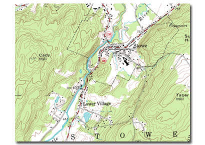
A topographic map is a type of map characterized by large-scale
detail and quantitative representation of relief, usually using contour
lines in modern mapping. It is a detailed and accurate graphic
representation of cultural and natural features on the ground.
However, in the vernacular and day to day world, the
representation of relief (contours) is popularly held to define the
genre, such that even small-scale maps showing relief are commonly
(and erroneously, in the technical sense) called "topographic."
Topographic maps supply a general image of the earth's surface:
roads, rivers, buildings, often the nature of the vegetation, the relief
and the names of the various mapped objects.
The study or discipline of topography, while interested in relief, is
actually a much broader field of study which takes into account all
natural and man made features of terrain.
Topographic maps have multiple uses in the present day: any type
of geographic planning or large-scale architecture; earth sciences
and many other geographic disciplines; mining and other earth-based
endeavours; and recreational uses such as hiking or, in particular,
orienteering, which uses highly detailed maps in its standard
requirements.
There are over 54,000 quadrangles (map sheets) that cover every
inch of the United States. The USGS' primary scale for mapping
topographic maps is 1:24,000. This means that one inch on the map
equals 24,000 inches on the ground, the equivalent of 2000 feet.
These quadrangles are called 7.5 minute quadrangles because they
show an area that is 7.5 minutes of longitude wide by 7.5 minutes of
latitude high. These paper sheets are approximately 29 inches high
and 22 inches wide.
Topographic maps use a wide variety of symbols to represent human
and physical features. Among the most striking are the topo maps'
display of the topography or terrain of the area. Contour lines are
used to represent elevation by connecting points of equal elevation.
These imaginary lines do a nice job of representing the terrain. As
with all isolines, when contour lines lie close together, they represent
a steep slope; lines far apart represent a gradual slope. Each
quadrangle uses a contour interval (the distance in elevation
between contour lines) appropriate for that area. While flat areas
may be mapped with a five-foot contour interval, rugged terrain may
have a 25-foot or more contour interval. Through the use of contour
lines, an experienced topographic map reader can easily visualize the
direction of stream flow and the shape of the terrain.
Most topographic maps are produced at a large enough scale to
show individual buildings and all streets in cities. In urbanized areas,
larger and specific important buildings are represented in black
though the urbanized area surrounding them is represented with a
red shading. Some topographic maps also include features in purple.
These quadrangles have been revised solely through aerial
photographs and not by the typical field checking that is involved
with the production of a topographic map. These revision are shown
in purple on the map and can represent newly urbanized areas, new
roads, and even new lakes.
There are now several publishers who produce digital versions of
federal government topographic maps - on CD-ROM, DVD or with an
on-line subscription. Each of these products may be used on a PC.
Some require additional navigation software to interface routes and
waypoints directly with a GPS Receiver. (The maps will not appear on
the screen of the GPS.)
Most Garmin and Magellan GPS receivers have an ability to show
maps in their display window. Straight from the factory these units
have a set of low resolution maps which most users decide are of
insufficient detail. However, it is possible to upgrade your maps. The
procedure is simple. Obtain the map software from the company that
manufactured your GPS, connect your GPS receiver to the computer
with a cable, select the maps you need with the software and click
a button that downloads the maps to your GPS. Your GPS will hold a
limited amount of detailed maps, depending mainly upon the amount
of memory and the type of maps that you are loading. Road maps
are much less detailed than topo maps, thus a larger coverage area
is possible with the same amount of memory.
|
|
|
|