|
|
 |
Knowledge Is Key
For Intelligent Decisions
Satellite Logic is a leading,
authoritative source of information in
the Satellite Industry. Located in the
heart of the Silicon Valley, Satellite
Logic provides one of the most
valuable and comprehensive
knowledge bases on the Satellite
market! This is a primary Worldwide
information center which enables our
clients to analyze, evaluate, inquire
and select their best tailored
solutions. Our company sets the
industry standards for targeted
buying leads, reflecting a dramatic
advance over traditional marketing
solutions.
|
|
|
 |

An aeronautical map is a map designed to assist pilots in navigating
an aircraft, just as a roadmap helps car drivers. Using these maps as
well as additional tools, pilots are able to determine their position,
safe altitude, best route to a destination, navigation aids along the
way, alternative landing areas in case of an in-flight emergency, and
other useful information such as radio frequencies and airspace
boundaries. There is a wide selection of aeronautical today, for all
land masses on Earth, as well as long-distance charts for trans-
oceanic travel.
Specific charts are used for each phase of a flight and may vary
from a map of a particular airport facility to an overview of the
instrument routes covering an entire continent (e.g., global
navigation charts), and many types in between.
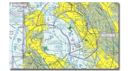
Sectional Aeronautical Charts are designed for visual navigation of
slow to medium speed aircraft. The topographic information featured
consists of the relief and a judicious selection of visual checkpoints
used for flight under visual flight rules. The checkpoints include
populated places, drainage patterns, roads, railroads, and other
distinctive landmarks. The aeronautical information on Sectional
Charts includes visual and radio aids to navigation, airports,
controlled airspace, restricted areas, obstructions, and related data.
World Aeronautical Charts cover land areas at a standard size and
scale for navigation by moderate speed aircraft and aircraft operating
at high altitudes. The topographical information includes city tints,
principal roads, railroads, distinctive landmarks, drainage patterns
and relief. The aeronautical information includes visual and radio
aids to navigation, airports, airways, restricted areas, obstructions
and other pertinent data. Because of their smaller scale, these
charts do not show as much detailed information as appears on the
Sectional and Terminal Area Charts.
|
|
|
|