|
|
 |
Knowledge Is Key
For Intelligent Decisions
Satellite Logic is a leading,
authoritative source of information in
the Satellite Industry. Located in the
heart of the Silicon Valley, Satellite
Logic provides one of the most
valuable and comprehensive
knowledge bases on the Satellite
market! This is a primary Worldwide
information center which enables our
clients to analyze, evaluate, inquire
and select their best tailored
solutions. Our company sets the
industry standards for targeted
buying leads, reflecting a dramatic
advance over traditional marketing
solutions.
|
|
|
 |

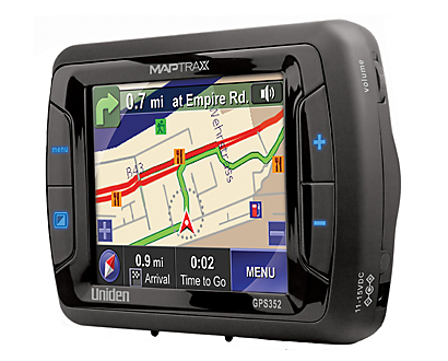
A GPS map is the software used in a GPS device that shows you
where you are in real-time, in a two-dimensional, geometrically
accurate representation of a three-dimensional space. GPS maps
use satellite technology to determine the precise location of a
person, vehicle, or any other asset the unit is attached to. Its
design allows the user to determine his distance from the
destination and the direction he should take in relation to certain
landmarks, streets, or places indicated in the virtual map.
GPS stands for Global Positioning System. This system is a global
radio navigation system that is comprised from the interaction of 24
satellites orbiting the Earth, along with their corresponding ground
stations. In the distant past, navigators and sailors would depend
on the stars to point them on their way to their destinations. Fast
forward to the present, through the use of modern technology of a
GPS map, travelers such as sailors, pilots and those who travel by
land no longer have to use the stars to guide them.
A GPS positioning system utilizes the orbiting satellites as reference
points in determining the distance from one point to another and to
find certain objects on the planet. With the use of satellite data, it
would be fairly easy to calculate the distance of a certain place to
another place.
When going for a hike in the woods, or driving through an unfamiliar
city, it is always a good idea to have a detailed map with you. Having
an accurate map that can show you the locations of various
landmarks, the lay of the land, or the network of routes, and it can
be a lifesaver when its late in the day or your feeling tired.
Today you have many choices for maps out there, including a
traditional paper map, an internet generated map, and even a GPS
map. Of these choices, perhaps the most versatile is that of a GPS
map. Why are GPS maps the best navigation choice in almost any
situation?
The GPS map's first advantage is that unlike a traditional paper map
or even an online generated map like Mapquest, a GPS map is a great
way to get an up to date picture of your area of interest. Paper maps
are not always updated and sometimes they are years old, and
possibly completely out of date. With a GPS map, you know you get
accurate information, based on real-time satellite data to make sure
your map is the most up to date it can be.
Although both paper maps and internet maps are many times
customized to meet your specific needs, you can even add more data
with a simple red marker or a yellow highlighter. Problem is that once
you mark the map, you cant really change it. Even if you use a pencil,
the erasure marks alone will eventually make the map unreadable,
and then youll have to buy a new one the next time you go out.
With a GPS map all you have to do is to download the related
information and save it.
Another great advantage of GPS maps is when you want to re-trace
your path. If your GPS map unit has the ability to track your progress,
simply pressing a few buttons on your device can easily show you
where you were, where did you come from and where you are.
Depending on the condition of your map, there is absolutely no
guarantee that youll be able to read the map let alone retrace your
steps.
All these advantages and many others make a GPS map a much
better choice when it comes to navigation. Moreover, many people
do not know what a GPS map is or even what GPS is capable of. In
the past GPS technology was reserved for large corporations of the
government but now consumers are becoming more aware and are
learning of its true potential.
Many people have heard about a GPS map but not many people
realize what they are or how they work. Most of the time, only
people who have traveled extensively such as pilots, navigators,
sailors and similar people would be most acquainted with GPS maps
because this kind of new technology is very essential in regards to
charter courses when you travel.
However, the military, researchers and various other people who
would have the need or desire to be aware of their exact locations
at any given time are also utilizing this kind of technology. On the
other hand, for the majority of ordinary people who would not want
or need to know about any systems or maps that could let them
know exactly where they are at any given point in time, GPS maps
are not as well known.
Today the GPS technology has become so advanced and precise that
it can calculate your position exactly down to the centimeter. For
instance, if you are using a GPS device to find a certain area
anywhere on the globe, it can pinpoint precisely where that area
is and what the distances is from where you are standing. The
exact nature of the technology within GPS systems is such that when
we refer to a GPS map, we can rest assured that the information we
can find within these GPS maps are easy to follow and accurate.
The GPS map has too many uses in our current society. For one thing,
the police department can help fight crime by using a GPS map; by
installing a GPS vehicle navigation system in police cars, the police
officer can easily respond to alerts in the city. GPS maps give police
and other government services the ability to find a way around the
city just as if they know every corner and every street by memory
alone.
|
|
|
|