|
|
 |
Knowledge Is Key
For Intelligent Decisions
Satellite Logic is a leading,
authoritative source of information in
the Satellite Industry. Located in the
heart of the Silicon Valley, Satellite
Logic provides one of the most
valuable and comprehensive
knowledge bases on the Satellite
market! This is a primary Worldwide
information center which enables our
clients to analyze, evaluate, inquire
and select their best tailored
solutions. Our company sets the
industry standards for targeted
buying leads, reflecting a dramatic
advance over traditional marketing
solutions.
|
|
|
 |

Marine navigation was for centuries celestial navigation, introduced
by the Portuguese. Prior to the development of celestial navigation,
sailors navigated by "deduced" reckoning. This was the method used
by Columbus and most other sailors of his era. At those days, the
ship's speed was measured by throwing a piece of flotsam over the
side of the ship.
Today marine tracking or vessel tracking is a more sophisticated
business. Marine tracking means nowadays to trace an object on
sea with the GPS. But unlike tracking objects on land, by which the
location data is mostly transmitted via cell/mobile phone systems,
at sea the only possibility to have access to the data are satellite
communication systems.
Marine tracking is obviously different from GPS tracking on land. GPS
works great at sea, because there are no canyons, nor trees that
block the weak signals from the GPS satellites. But unfortunately
there are no cell-towers at sea neither. So to communicate the
output of a GPS receiver to a station on land, one cannot use cellular
phone networks. Once a ship is 8 to 10 miles off-shore, any cellular
phone ceases functioning. However there are many different
satellite communication services that can assure the communication
between the ship and land-stations.
All ships over 500 gross tons are required to be equipped with a
Ship Security Alert System (SSAS), which is capable of discreetly
raising the alarm to the relevant authorities and tracking the vessel
if the security of the vessel is compromised. This is part of marine
tracking.
Under the Global Maritime Distress and Safety System (GMDSS), all
passenger ships, carrying more than twelve passengers, and all
cargo ships over 300 gross tonnage on international voyages have
to carry specified satellite and radio-communications equipment, for
sending and receiving distress alerts and maritime safety information,
and for general communications. The exact suite of equipment
depends upon the intended routes of the ship.
Coastal vessels, for example, only have to carry minimal equipment if
they do not operate beyond the range of shore-based VHF radio
stations, but they may carry satellite equipment. However, some
coasts do not have shore-based facilities, so although the ship is
close to the shore, the area counts as Area A2 or A3. Ships which do
go beyond Sea Area A1 have to carry MF equipment as well as VHF -
or Inmarsat satellite equipment. Ships which operate beyond MF
range have to carry Inmarsat satellite equipment in addition to VHF
and MF. Ships which operate in area A4 have to carry HF, MF and
VHF equipment.
The IMO also introduced digital selective calling (DSC) on VHF, MF and
HF maritime radios as part of the GMDSS system. DSC is primarily
intended to initiate ship/ship, ship/shore, and shore/ship
radiotelephone and MF/HF radio telex calls. DSC calls can also be
made to individual ships or groups of ships. DSC distress alerts,
which consist of a preformatted distress message, are used to
initiate emergency communications with ships and rescue
coordination centers.
IMO and ITU both require that the DSC-equipped VHF and MF/HF
radios be externally connected to a satellite navigation receiver. That
connection makes marine tracking possible and will ensure accurate
location information is sent to a rescue coordination center if a
distress alert is ever transmitted.
The Coast Guard believes VHF, MF and HF radiotelephone equipment
carried on ships should include a DSC capability as a matter of safety.
To achieve this, the FCC requires that all new VHF and MF/HF
maritime radiotelephones type accepted after June 1999 to have at
least a basic DSC capability.
To further enhance safety, interfacing a GPS or Loran with the DSC
radio is highly recommended. The automated Distress message
usually provides information as to the identity of the vessel, nature
of the distress, location of the vessel, and sounds an alarm at other
DSC equipped stations.
Once you have connected a GPS receiver or chartplotter to your DSC-
equipped radio, you should also use it for navigation, of course, but
marine tracking is the real goal.
As an example, Andronics' Ltd. marine tracking lets you access
information on your vessels position, speed and direction of
travel at any time by simply logging onto a dedicated, secure
website. LEO-Marine equipment uses Low Earth Orbit satellites for
communication, GPS and the Internet for a cost-effective, reliable,
global fleet management system. Marine tracking for private yacht
owners and commercial fishing fleets.
SASCO Inc. uses Orbcomms low earth orbiting communication
satellites for an economical Satellite Communications and Marine
Tracking solution for the Marine Industry. For Commercial Fishing/
Shrimping Trawler Fleets, the Trawler Fleet Tracker enables you to
get vessel positions, voyage tracking, and catch information. The
built-in messaging system allows private communications between
your office and the vessels in your fleet.
Affordable two-way email communication at sea enables you to stay
in contact with your crews. Advantages include: Weather reports
and advisories, itinerary changes and instructions, safety purposes,
and personal messaging.
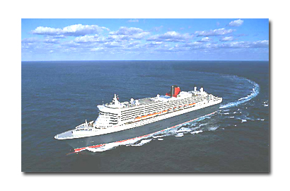
On a Recreational Cruise you can send and receive text messages
to and from your family and friends on the Internet. Positioning
interval option would maintain your most recent position that may
be forwarded to a designated recipient of your choice.
Satamatics technology and services provide seamless worldwide
coverage for the remote marine tracking of maritime vessels,
whether in port or on passage in any ocean. The on-board
communications technology, which utilizes Satamatics ultra-compact
SAT 101 satellite terminal, enables the location, speed and heading
of vessels to be tracked and monitored from any desktop or laptop
with Internet connection.
Information delivery is via Inmarsats constellation of communication
satellites, providing operators, owners and crew with accurate
reports of their vessels position and status, wherever they are. The
service can include sending position reports to a marine tracking
application, and the automatic delivery of programmed warnings to
indicate alerts, alarms or incidents that warrant action.
World Communications Center (WCC) offers a marine tracking
system that not only meets the Ships Security Alert System (SSAS)
regulations, but allows for an end-to-end solution for possible
policies to come. Using ASEs MariTrack, monitor the transportation
of your fleets via the Internet using Iridiums truly global all-digital
satellite technology.
Custom Tracking marine tracking solutions are designed specifically
to address fishing fleet requirements. It combines GPS, satellite
communication, instant messaging and web-based mapping, that
provides the fleet manager accurate information about the activities
of his vessels on a day to day basis.
If you are running a boating hire business, such as house boats or
pleasure yachts, the Custom Tracking system will allow you to
identify the exact location, travel speed and direction of each of your
vessels. Additionally the system can report on the bilge pump, fuel
levels and battery power so that your hirers never get stranded.
As there are no cell towers in the middle of the oceans, normally one
could not use his mobile phone at sea. But all ships that cross the
ocean do have mandatory satellite communication equipment on
board. If one cell phone base station would be placed on board of
the ship that could use the satellite communication channels to
communicate with a cellular network on land, every cell phone on
board could function normally.
Many containers are already equipped with tracking devices. Almost
without exceptions these devices use GPS and wireless cellular
technologies. However this means that, as soon as a ship with
containers goes offshore, these devices do not function anymore.
For position tracking this is not so important as the position of the
ship will be known, but for security reasons these devices often
track whether a door is opened, watch the temperature inside
containers, etc.
|
|
|
|